Monday, June 4, 2012

We Chose Wisely!


30-35 Knot Winds in Humboldt Bay
Speed and Wind Direction Weather Chart
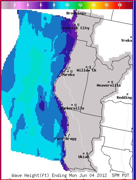
Wave Height Weather Chart

Adding Ball-Fenders
We had planned to leave early this morning for the 13-hour cruise to Fort Bragg, the first safe harbor south of Eureka.  This would be a long journey and we would be rounding the notorious Cape Mendocino.  At 6am Humboldt Bay was quiet and the sun was peeking through; it looked to be a nice day, but the weather report and weather graphs presented a much different picture.  After careful study and consideration, we decided not to leave.  The wind and waves started to kick up around 9am, and by 11am we had 30 to 35 knot winds in the bay!  We added extra lines to better secure the boat and added big ball-fenders to help hold the boat away from the dock.  The wind and waves were so strong that the boat was being pushed up against the dock risking damage to the hull and rub-rail.  By the time we were finished, we had eight fenders and eight lines holding the boat.  We must have spent 40 minutes securing the boat, getting soaking wet from the waves splashing over the dock.  After we completed the task the winds started to subside.  It illustrated how quickly things can change.  Before leaving port, we always go through a fairly lengthy process of planning a route and checking the weather charts and predictions.  Boaters need to know what the wind, waves, and currents will be over a period of time and at various locations, including the final destination.  Leonard uses the Coastal Explorer Navigation software, in the “planning mode,” to lay out the desired route.  Using the planned route with a planned speed and departure time, we can determine the estimated time of arrival at the next port, and at various points along the way.  Based on our arrival time and the river bar forecasts, we can determine what the tides and currents will be.  Boaters can also determine conditions at various points along a route by using the Tidal Level and Tidal Current stations.  These stations or positions that are marked on nautical charts provide tidal water level and tidal current measurements in the form of prediction tables.  Equally important are the wind and wave forecasts obtained from the National Weather Service and the NOAA Service, which are updated every six hours.  These forecasts predict the height of wind waves and separately the height and time period of ocean swells.  Wind speed is also provided with a range indicated in knots.  Of course this information needs to be collected and interpreted by the captain and crew in order to make a “go” or “no-go” decision based on the predictions, type of vessel, and comfort level.  A contributing factor is the angle of approach waves will be meeting the boat - off the bow, stern, or from the side.  To help make the final go, no-go decision, one needs to know what is happening at sea in the here and now.  That’s where weather buoys come in.  These buoys contain automated devices that measure wave height and wave period and sometimes wind speed; this information is transmitted via radio or satellite communication to weather centers, where boaters can pick up the information through the internet.  When ready to leave port, we always keep four rules in mind (1) don’t go by appearances, always check the weather, (2) don’t be in a rush to get somewhere, (3) understand the sea worthiness of the boat, and (4) have a backup plan.  Later this evening, a sailboat arrived and tied-up behind us.  Leonard went over to chat and learned they had just sailed down from Crescent City in sustained 30-35 knot winds!  They lost their radar reflector off the mast and encountered breaking waves 8 miles out to sea, and 10 foot waves coming over the bar.  Boy! Are we glad we didn’t go!
Weather Buoy Chart and Advisory
Weather Buoy

1 comment:

  1. Okay, THIS got my attention! I hope hot cocoa was enjoyed by all hands after your time in the wind and rain :-)

    ReplyDelete