Friday, June 15, 2012

The Birds


Village of Bodega Bay and Taylor Street
Birds Arriving at Dusk
Seagulls rule at Bodega Bay
We enjoyed our time in Bodega Bay with its pretty undulating barren hillsides and we were fascinated by the strange behavior of the birds.  Each evening, seagulls would begin to congregate along the finger piers next to our boat.  As the evening wore on, more and more birds arrived and by nightfall, dozens of seagulls were standing on the docks all facing the same direction.  The birds were gone by morning but would return each evening for their nightly ritual.  The following afternoon, we bicycled into the village of Bodega Bay and had lunch at the Tides Restaurant.  We found a picnic table overlooking the water and the birds started gathering around the wharf.  One bird hopped up on our table and looked directly in our face as if to say “give me some food or else.”  Perhaps these birds knew they had famous ancestors.  After all, Alfred Hitchcock chose Bodega Bay for the setting of his 1963 horror movie, “The Birds.”  One of the opening scenes in the movie shows actress Tippi Hedren driving into Bodega Bay on the winding scenic road above town, the scenery from Bay Hill Road appears much the same today.  The Tides Restaurant, which has since been rebuilt, was used for the gas station, cafĂ©, and boat dock scenes.  Many of the shots of children running from the Potter School House were made on Taylor Street in the village of Bodega Bay.  The school house, now a private residence, is located in the town of Bodega six miles to the southeast.  Hitchcock wanted a quiet fishing village, fog, and stark looking hills for his horror movie and Bodega Bay fit the bill.  After our own encounter with the birds, we decided to watch the movie that night while the birds huddled just outside our windows.  Tourists still come to see the birds both literally and figuratively speaking and Tippi Hedren still makes regular visits to Bodega Bay for autographs.  Bodega Bay indeed has lots of birds and is home to over a 100 species, including cormorants, pelicans, terns, egrets, willets, oystercatchers, and numerious other species of birds.  It’s been said that more rare birds have been spotted in Bodega Bay than in any other area in Sonoma County, making Bodega Bay a bird watcher's paradise.
Birds Gathering at the Wharf
Give me food or else!
Potter School House Residence

Tuesday, June 12, 2012

Not as Advertised


Big Ocean Swells!
Contending with "Following Seas"
We left Fort Bragg at 6am with forecasted favorable conditions at our depature and a forecast of 15 to 25 knot winds further south near our destination, certainly acceptable conditions for our boat, Got d’ Fever.  We left Fort Bragg with 6-9 foot swells at the entrance and similar seas several miles out.  The sea swells subsided later in the morning to 6 feet, then down to 4-5 foot swells so we set the boat on auto pilot.  The weather window was working well, or so we thought.  Some fog crept in around 9:15am and the winds picked up to 18 knots with 6-8 foot swells as we neared Point Arena, still not a concern as Got d’ Fever can handle these conditions quite well.  Around noon, however, the wind increased to 30 knots with 10 foot swells.  The fog had lifted and we saw clouds rushing by overhead.  As time went on, the winds were over 30 knots (not as forecasted) with 11-12 foot ocean swells.  This meant concentrated hand steering; “we’ll have to go manual,” to take a quote from Apollo 11.  We were in the worst sea conditions we had ever experienced; and since the next safe harbor was still about 3 hours away, we were committed.  Got d’ Fever continued to handle these "following seas" surprisingly well and we marveled at her capability, what a great boat!  Then we were presented with a serious challenge requiring steadfast teamwork.  A large wave pitched the boat sharply over to the side; the dinghy on the boat deck came off one of its supports and a strap came loose.  The bow of this 400 lb. dinghy was sliding off to one side with the risk of sliding further and causing more damage or upsetting the balance of Got d’ Fever.  Leonard put on his life jacket and went top side - using the davit system, he got the dinghy back on the support block and lashed down.  I was handling the steering, keeping an eye fixed on a point at the horizon to keep the bow pointed straight ahead as much as possible.  Turning the wheel quickly from side to side took lots of muscle and concentration.  My mouth was getting dry and I was terribly thirsty.  Thank goodness Leonard returned safely to the pilot house.  Too bad Java wasn't able to take pictures of the whole event; she seemed oblivious to what was going on.  We surmised that the cooler air had deflated the dinghy just enough to loosen the straps.  Yes, we’ve decided to add extra straps – front to back as well as side to side.  We made our way into Bodega Bay to Spud Point Marina tucked just inside Bodega Harbor.  The wind was blowing 27-30 knots in the harbor, presenting us yet another challenge after ten and a half hours of motoring.  We managed to get the boat into a slip and secured the lines – the day’s adventure was now over.  We would be here for the next several days, waiting out predicted 40 knot winds.
Arriving in Bodega Harbor
Bodega Harbor Village

Sunday, June 10, 2012

Enjoying the Wait


Kayak Trip up the Noyo River
Deer along the banks of the Noyo River
We spent a week at Fort Bragg waiting for favorable wind and wave conditions to continue our next leg down the West Coast to Bodega Bay, a 12-hour journey.  Reports of gale-force winds and 13-foot seas kept us in port.  We used the time in Fort Bragg to work on some boat projects, including varnishing the cap rails, and waxing the boat inside and out! Whew!  Yes, we took some days off and checked out the cute shops and intriguing fish processing operations that make up old Fort Bragg.  We also took a short kayak trip up the Noyo River and found it to be very picturesque with a mix of evergreen trees and stands of beautiful old eucalyptus trees.  The variety of wildlife in the area proved to be a real treat.  We saw deer, Eagles, and Great Blue Heron.  Three Sea Lions came to visit each day and stood guard on a neighboring dock near our boat.  They would frequently bark and were so loud that Java had to join the chorus.  We also saw Brown Pelicans, who put on quite a show while we were having lunch with our friends Pat and Lisa aboard their sailboat, a 42ft. Hunter named Always & Forever.  We watched a Brown Pelican swallow a large fish while Sea Gulls tried to pull the fish from the Pelican’s beak.  We humans were somewhat more dignified when it came to eating our fresh crab and fruit salad. 
Sea Lions resting after their Serenade
Intriguing Fort Bragg and Noyo River
Pelican and Sea Gulls fighting over Lunch
Pelican Swallowing a Big Fish
Time with friends, Pat and Lisa

Wednesday, June 6, 2012

The Charm of Fort Bragg

Narrow Rocky Entrance
Passing Under Hwy 1 Bridge
We left Eureka at 6:45am to take advantage of the good weather window for our 13 hour cruise to Fort Bragg, not the one in Virginia of course.  We encountered 7-8 foot swells over the Humboldt Bar as we departed Eureka and 4-5 foot swells outside the bar.  The notorious Cape Mendocino and Punta Gorda turned out to be a non-event with only 2-foot seas.  To our delight, Dall Porpoises appeared and rode the waves alongside our bow, checking out the boat as if to prove they could swim faster than our strange man-made contraption.  By the time I got my camera out, they were gone.  As we passed Point Delgada and Shelter Cove, the winds shifted direction and we had “following seas” with 6-7 foot swells and 20 knot winds.  The boat handled the conditions well but we knew it would be tricky getting into Fort Bragg with waves pushing us from behind.  The entrance at Fort Bragg into Noyo River is very narrow with rocks lying on both sides of the small opening – it took our full attention to watch the channel ahead, keep an eye on the charts, and hands on the wheel.  Once through this narrow entrance, we passed under the Hwy 1 bridge then made a sharp turn to starboard and continued down the narrow channel, winding our way to the Noyo Mooring Basin.  Cafes, restaurants, and work sheds line both sides of the channel up to the mooring basin – it’s absolutely charming and looks more like a village in Alaska than a town in California.  No wonder Hollywood shot scenes here for the movie “Overboard.”  We recognized several of the buildings and had to watch the movie again that night.  The bridge has been replaced since the movie was made but the town is much the same.  It was an interesting day, including our encounter with Pat and Lisa, the sailboat couple we had met in Eureka.  They too had made the weather window for their cruise south and moored at Noyo Basin.  They came over to our boat to say hello and we had a great visit with them over coffee and cake.  As it turns out, they are headed for Mexico as well and we hope to meet up with them again.

Charming Fort Bragg and the Noyo River
Looking out to the Pacific
Aerial View of Fort Bragg and Noyo River

Monday, June 4, 2012

We Chose Wisely!


30-35 Knot Winds in Humboldt Bay
Speed and Wind Direction Weather Chart
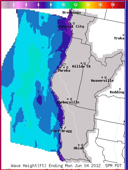
Wave Height Weather Chart

Adding Ball-Fenders
We had planned to leave early this morning for the 13-hour cruise to Fort Bragg, the first safe harbor south of Eureka.  This would be a long journey and we would be rounding the notorious Cape Mendocino.  At 6am Humboldt Bay was quiet and the sun was peeking through; it looked to be a nice day, but the weather report and weather graphs presented a much different picture.  After careful study and consideration, we decided not to leave.  The wind and waves started to kick up around 9am, and by 11am we had 30 to 35 knot winds in the bay!  We added extra lines to better secure the boat and added big ball-fenders to help hold the boat away from the dock.  The wind and waves were so strong that the boat was being pushed up against the dock risking damage to the hull and rub-rail.  By the time we were finished, we had eight fenders and eight lines holding the boat.  We must have spent 40 minutes securing the boat, getting soaking wet from the waves splashing over the dock.  After we completed the task the winds started to subside.  It illustrated how quickly things can change.  Before leaving port, we always go through a fairly lengthy process of planning a route and checking the weather charts and predictions.  Boaters need to know what the wind, waves, and currents will be over a period of time and at various locations, including the final destination.  Leonard uses the Coastal Explorer Navigation software, in the “planning mode,” to lay out the desired route.  Using the planned route with a planned speed and departure time, we can determine the estimated time of arrival at the next port, and at various points along the way.  Based on our arrival time and the river bar forecasts, we can determine what the tides and currents will be.  Boaters can also determine conditions at various points along a route by using the Tidal Level and Tidal Current stations.  These stations or positions that are marked on nautical charts provide tidal water level and tidal current measurements in the form of prediction tables.  Equally important are the wind and wave forecasts obtained from the National Weather Service and the NOAA Service, which are updated every six hours.  These forecasts predict the height of wind waves and separately the height and time period of ocean swells.  Wind speed is also provided with a range indicated in knots.  Of course this information needs to be collected and interpreted by the captain and crew in order to make a “go” or “no-go” decision based on the predictions, type of vessel, and comfort level.  A contributing factor is the angle of approach waves will be meeting the boat - off the bow, stern, or from the side.  To help make the final go, no-go decision, one needs to know what is happening at sea in the here and now.  That’s where weather buoys come in.  These buoys contain automated devices that measure wave height and wave period and sometimes wind speed; this information is transmitted via radio or satellite communication to weather centers, where boaters can pick up the information through the internet.  When ready to leave port, we always keep four rules in mind (1) don’t go by appearances, always check the weather, (2) don’t be in a rush to get somewhere, (3) understand the sea worthiness of the boat, and (4) have a backup plan.  Later this evening, a sailboat arrived and tied-up behind us.  Leonard went over to chat and learned they had just sailed down from Crescent City in sustained 30-35 knot winds!  They lost their radar reflector off the mast and encountered breaking waves 8 miles out to sea, and 10 foot waves coming over the bar.  Boy! Are we glad we didn’t go!
Weather Buoy Chart and Advisory
Weather Buoy

Sunday, June 3, 2012

The Old Cookhouse

Samoa Cookhouse

Cookhouse Dining Room
Enjoying Breakfast at the old Cookhouse
On our third day in Eureka we bicycled to the Samoa Peninsula (a long sandy stretch of land 9.5 miles long and one mile wide), the land barrier that separates northern Humboldt Bay from the Pacific Ocean.  Samoa was the site of a mill town and today the site of the last surviving mill cookhouse in the West – the cookhouse first opened in 1893.  The Samoa Cookhouse still serves breakfast, lunch, and dinner lumber camp style – a set menu with no limit on second’s.  We arrived for breakfast after biking across three bridges to the Peninsula, a scary adventure due to the narrow shoulder and fast moving traffic.  In the early 1900’s, mill workers could simply walk to the cookhouse from their adjacent company housing units.  “Come and get it” was the familiar cry heard at the Hammond Lumber Company cookhouse, a busy place crowded with hungry men.  Meals were served family style at long tables covered with oil cloth, ten men to a table.  The girls who worked at the cookhouse were required to reside in the upstairs dormitory in order to work seven days a week, providing three hot meals a day.  Each Thursday, everyone provided labor to clean the floors – the wooden floors got splintered and scarred by the calked (spiked) boots, trapping food and dirt.  The floors today are covered in linoleum.  Historic photographs from the old logging and cookhouse days adorn the walls, and relics from the era are displayed in several rooms.  Andrew Hammond purchased the Vance mill property in 1900 and continued buying timber land, expanding production facilities and size of the operation over 56 years, creating the nations largest redwood lumber mill.  Georgia Pacific Corporaton purchased the Samoa sawmill complex in 1956 and began operation of a plywood mill in 1958.  Some of the older worker housing was razed during construction of modern mill facilities but the Samoa Cookhouse was preserved. 

A Mighty Big Tree!
The Old Cookhouse

Lumberman's Calked Boots

Saturday, June 2, 2012

Eureka! We Found It

Eight Hours of Fog
Thank Goodness for Radar and AIS
Beautiful Humboldt Coast Guard Station
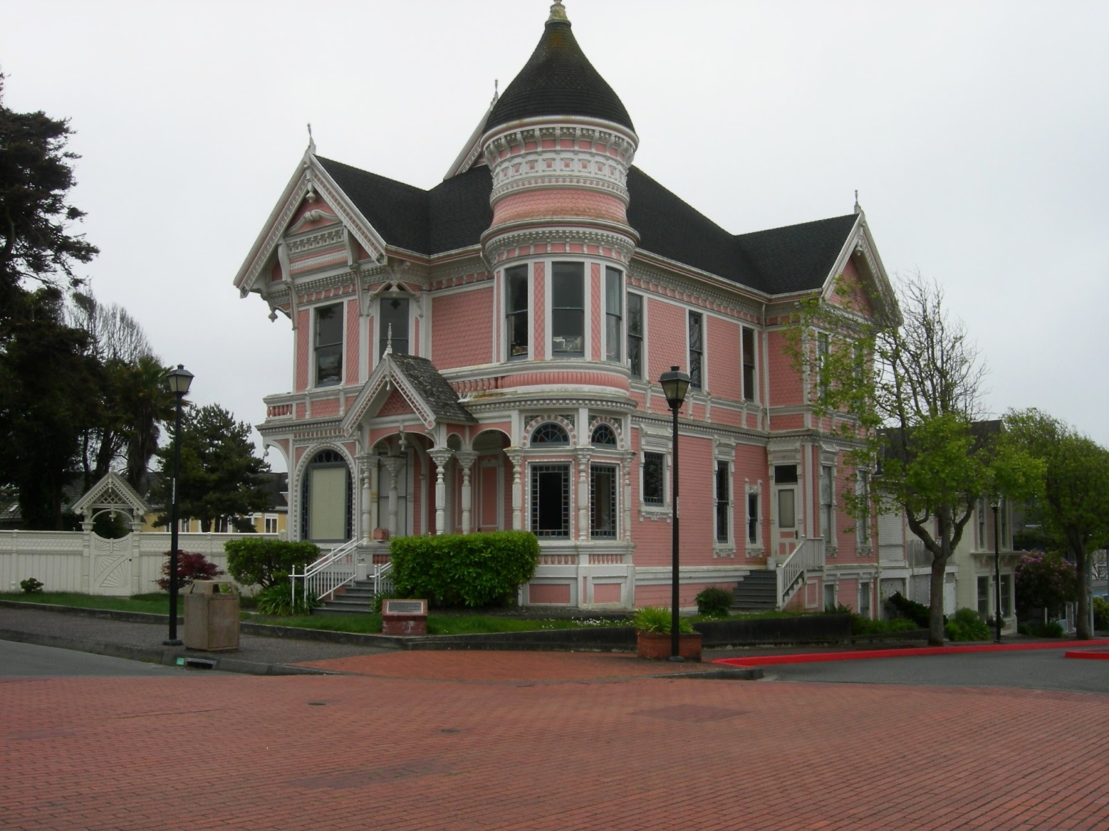
We had calm seas when we departed Crescent City but we were shrouded in fog - 8 hours of looking at fog all the way to Eureka!  Interestingly, Eureka is a Greek word meaning “I have found it!”  Yes, we found our way through the fog into Humboldt Bay.  Thank goodness for radar and AIS which enabled us to safely go around two boats.  The most challenging was avoiding a large ship that was going in and out of the channel dredging the Humboldt River Bar.  Our AIS (Automatic Identification System) gave us an early detection that this large ship was approaching our path.  After we took the appropriate evasive action, we continued into Humboldt Bay, passing the beautiful Coast Guard Station and docked at the Eureka City guest dock.  We were greeted by Brown Pelicans swooping overhead, and Sea Lions that occupied the dock along with Great Blue Herons.  In the morning we bicycled to “Old Town,” the restored district of mid-1800’s buildings that house various shops, pubs, and cafes.  Beautiful Victorian homes can be seen in this historic district, including the famous Carson Mansion constructed 1884-1885.  William Carson came from Canada looking for gold after it had been discovered in 1848 in nearby Trinity River.  This venture proved unsuccessful and William turned to the abundant Redwood forests; by 1854 he was operating a mill.  In 1863 he formed the Dolbeer and Carson Lumber Co. in partnership with John Dolbeer, who later invented the Steam Donkey Engine in 1881 which revolutionized logging.  The beautiful Carson Mansion is a mix of every major style of Victorian architecture, primarily Queen Anne, and is considered the grandest Victorian home in America.  Until 1950, the mansion was owned by the descendants of William Carson after which it was sold to the Ingomar Club, an exclusive member’s only club.  Located across the street is “The Pink Lady,” a house built in 1889 for William’s son, John Carson, as a wedding present.  Other lovely Victorian and early American homes in the area include Carson’s first Eureka home, a simple but most beloved home of Sara, William’s wife.  On our way back to the boat, we biked along the boardwalk overlooking Eureka Channel.
"Old Town" Eureka
Carson Mansion
The Pink Lady
Riverfront Boardwalk